 Saifullah Ahad
How I built it
 Muganhu: Land BoundaryLive on Google Play
Muganhu: how to measure land area with phone GPS
To learn how to measure land area with phone GPS, you need to understand why standalone phone positioning drifts several metres under changing satellite conditions. Muganhu coordinates two Android phones over a direct local link, using raw satellite observations to cancel atmospheric errors, track live uncertainty, and verify traverse closure.
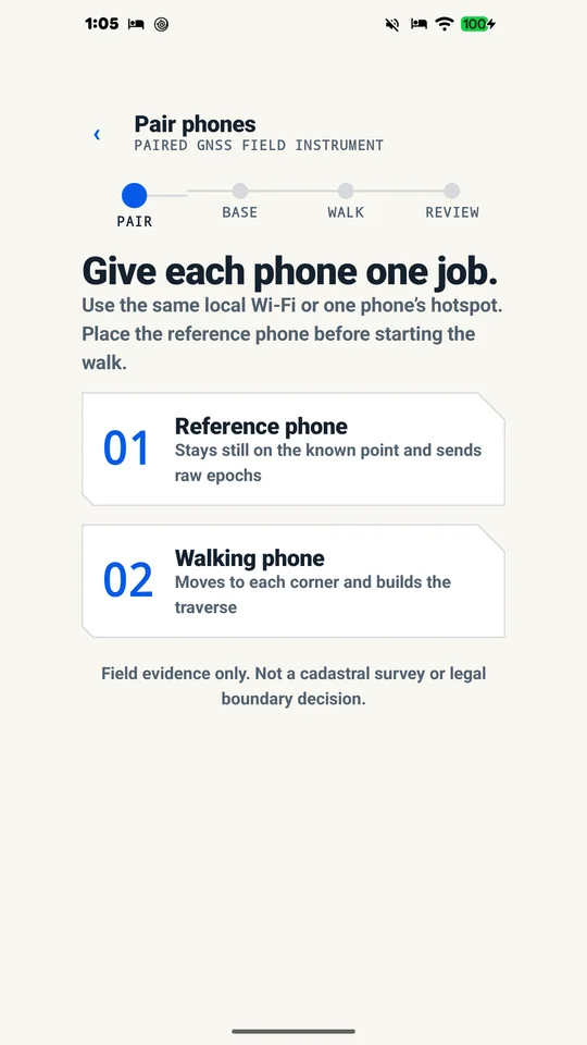
01
The problem: single-phone GPS wander on property perimeters
Measuring a field boundary with a single smartphone sounds straightforward until you inspect the numbers. Standard consumer phone location fixes rely on uncorrected satellite signals travelling thousands of kilometres through the ionosphere and troposphere. Minute atmospheric delays, satellite clock drift, and signal reflections cause a standalone phone’s reported coordinates to wander continuously, even when the handset is held completely still on a fence post.
When walking a property perimeter, this five-metre radius of uncertainty compounds at every turn. Corners recorded with drifting coordinates warp the polygon’s interior angles, stretch or shrink boundary lengths, and produce wildly inconsistent area calculations between repeated passes. For smallholders and field managers planning fencing, seedling orders, or trenching, an unanchored phone fix provides little confidence.
02
The plan: a paired-phone traverse with raw satellite observations
Professional surveyors solve atmospheric drift by using differential GNSS: one receiver remains stationary on a known point while a second receiver moves to the boundary stations. Because both receivers view the same satellite constellation through nearly identical columns of air, subtracting the stationary base’s observations from the rover’s observations cancels common-mode atmospheric errors.
The concept for Muganhu—named after the Shona word for a boundary or limit—was to apply this differential principle using two ordinary Android smartphones without external surveying hardware. One phone sits stationary on a reference point with an unobstructed sky view. The second phone walks the boundary. By connecting the phones directly over the same local Wi-Fi network or mobile hotspot, raw satellite measurements stream between them to calculate relative baselines, real-time horizontal uncertainty, and traverse closure.
03
The build: epoch alignment, robust weighting, and float carrier smoothing
Modern Android devices (Android 7.0 and newer with supported chipsets) expose raw GNSS clock and measurement observables via the platform location APIs. Muganhu taps directly into these raw pseudorange and carrier-phase streams instead of reading pre-filtered location coordinates. The reference phone packages its raw satellite epochs and streams them to the walking phone over a direct local socket encrypted with AES-GCM and authenticated by a four-digit session code.
Because the two phones run independent internal clocks, Muganhu uses round-trip ping-pong samples over the local link to estimate clock offset and link latency, rejecting communication delays exceeding 700 milliseconds. The baseline solver requires at least four shared satellites, weights each observation by satellite elevation and signal-to-noise ratio (C/N0), and applies carrier-phase smoothing while estimating float ambiguities. Outlier signals caused by multipath interference are filtered through two iterative passes using median absolute deviation of residuals.
04
The field session: real-time settling, geometry, and traverse closure
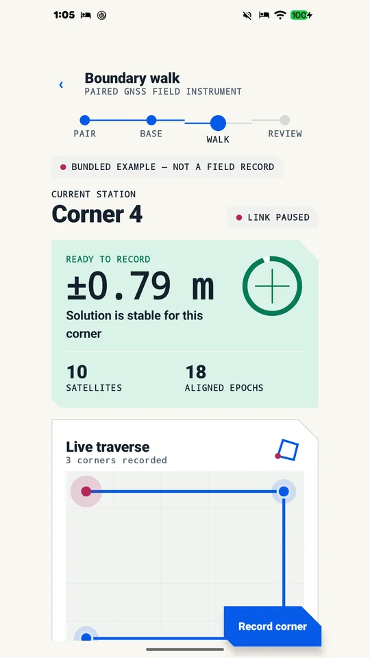
Field work demands clarity in harsh sunlight. Muganhu organizes the measurement process into a clear four-step sequential traverse spine: PAIR, BASE, WALK, and REVIEW. During the walk, the app continuously evaluates solver convergence. When arriving at a corner, the user pauses; the interface displays the live horizontal uncertainty (such as ±0.79 m in the store demonstration) and only indicates “READY TO RECORD” once the solution stabilizes.
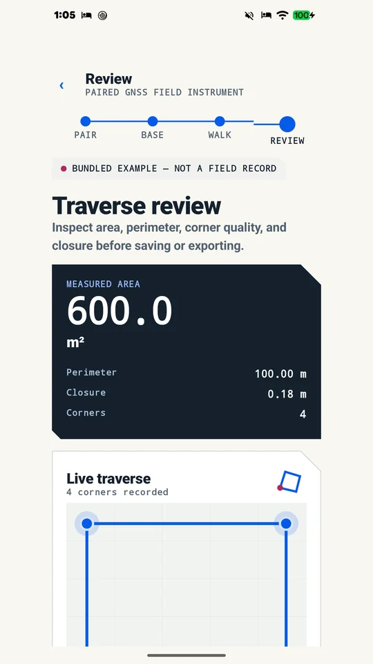
As each corner is captured, the live traverse diagram updates on screen. When the user returns to the starting station to close the loop, Muganhu computes the traverse closure discrepancy—the distance between the initial station and the return fix—along with total perimeter and parcel area using standard coordinate geometry. The result can be displayed across six regional land units: square metres, hectares, acres, decimals, Bangladesh katha, and Bangladesh bigha.
05
What was tested, and what was not
The mathematical engine was verified using automated unit tests covering a known 5 m east × 12 m north × 0.7 m up raw-observation baseline (13.00 m horizontal distance) and a known 20 × 30 m rectangle (600.00 m² area, 100.00 m perimeter, four 90° angles, and 0.18 m closure). On 15 August 2026, release verification on an Infinix Note 8 (Android 10) and Galaxy Tab S3 (Android 9) confirmed successful local pairing, authenticated encrypted transport, and zero fatal crashes. The bundled solver replay executed on both devices with zero displayed error.
The limits are clear and honest: As stated in the app’s verification records, the deterministic replay validates mathematical computation but cannot establish physical antenna or site performance. A live physical ground-truth test on a tape-measured outdoor boundary under open sky was not part of the release verification run. Internal smartphone antennas vary significantly, and carrier phase is float-only without centimetre-level integer ambiguity resolution. Muganhu is a field planning and measuring instrument, not a cadastral survey; it does not adjudicate legal boundaries or resolve property disputes, which strictly require a licensed surveyor or the official land records office.
06
Where it stands
Muganhu is live on Google Play under package ai.saifullah.muganhu. It provides smallholders and field workers with a structured two-phone instrument for measuring boundary traverses, checking closure error, and exporting PDF reports, CSV tables, or JSON records secured by an on-device SHA-256 epoch hash chain.
What this shows about how I work
- Consumer GPS drift makes single-phone boundary measurement unreliable; pairing two devices allows cancelling common-mode atmospheric errors.
- Traverse closure and live uncertainty metrics give immediate feedback before saving a plot.
- Engineering tools must state their boundaries plainly: mathematical solver verification does not replace real-world physical site constraints.
How to measure land area with phone GPS
Measuring field perimeters with mobile devices requires understanding the physical constraints of satellite positioning. Follow these practical steps to collect reliable boundary measurements using your smartphone.
1. Verify sky visibility and atmospheric clearance
Satellite positioning accuracy depends fundamentally on line-of-sight signal reception. According to official U.S. government performance data on GPS.gov on GPS accuracy, “GPS-enabled smartphones are typically accurate to within a 4.9 m (16 ft.) radius under open sky.” Accuracy degrades significantly near dense tree canopies, tall buildings, or metal fences due to signal blockage and multipath reflections. Before measuring, ensure your parcel boundaries have an open view of the sky.
2. Settle on each corner before recording coordinates
Do not record points while walking continuously along the fence line. When you reach a boundary corner, stop and hold the handset completely motionless directly over the corner marker for twenty to thirty seconds. This settling period allows the internal GNSS receiver to filter out momentary velocity noise and accumulate sufficient satellite epochs to stabilize the coordinate fix.
3. Walk the perimeter in sequential order to measure land with GPS
To accurately measure land with GPS, traverse each boundary station in strict sequential order (clockwise or counter-clockwise) around the entire perimeter. Skipping across the plot or recording corners out of order will create self-intersecting polygons and invalidate geometric area calculations. Keep a consistent phone orientation and height at every corner station.
4. Return to your starting corner to check traverse closure
A reliable boundary measurement requires a closed traverse loop. When you finish recording all perimeter stations, return to the exact physical location of your first corner and record a closing reading. The distance between your initial station and your closing fix is your closure error. In surveying, closure error indicates whether satellite drift occurred during your walk; an excessive closure gap warns you that atmospheric or satellite conditions shifted while you surveyed.
5. Compute parcel area using coordinate geometry
Once all boundary coordinates are logged and closure is confirmed, calculate the enclosed polygon area using coordinate geometry (the shoelace formula). Multiply the easting and northing coordinates of adjacent stations in order, take the absolute difference of cross-products, and divide by two to obtain the enclosed area in square metres before converting into regional units such as hectares, acres, or decimals.
6. Recognize the legal limits of a land boundary measurement app
While a smartphone land boundary measurement app is valuable for planning irrigation, estimating fencing material, or mapping crop plots, consumer phone GPS cannot settle legal property lines. Standalone consumer receivers have an inherent uncertainty radius of roughly five metres. For official title registration, deed mapping, or resolving boundary disputes with neighbours, property owners must engage a licensed professional land surveyor or consult the government cadastral survey office.
How the app helps: Muganhu pairs two phones over a direct local link to cancel atmospheric drift with raw GNSS single differences, displaying live uncertainty, closure error, and geometric area across six land units directly on the phone.
More build stories: How to check a used phone before buying · How to check if your electricity meter is running fast · Eelj: a fair turn for a village’s one harvester · Practicing stuttering techniques at home · Where and when to look for the new crescent moon · How to split electricity bill with roommates · Milk fat SNF rate calculator, step by step · How to check a link before you click it · How to calculate cattle weight without a scale · How to settle who owes who in a group · Braille translator that explains every cell · Math learning gaps: where to start when a child is stuck · How to describe a car noise so a mechanic can find it · Convert Rumi to Jawi, then check the spelling · How to sync SRT subtitles with video · Quran pronunciation app, tap any word to hear it · Lipi: Bangla keyboard, side by side with Ridmik · How to check an overseas employment contract · Extract data from graph image on Android
Open to work
Let's build your AI product system.
Full-time roles — remote anywhere, hybrid in Bangladesh, or on-site abroad: AI Product Builder, AI Product Manager, AI Workflow Orchestrator, Product Delivery Lead. 250+ apps live on Google Play are the proof.
Based in Dhaka, Bangladesh (UTC+6) · works any time zone · can start now · ready to relocate with visa sponsorship.